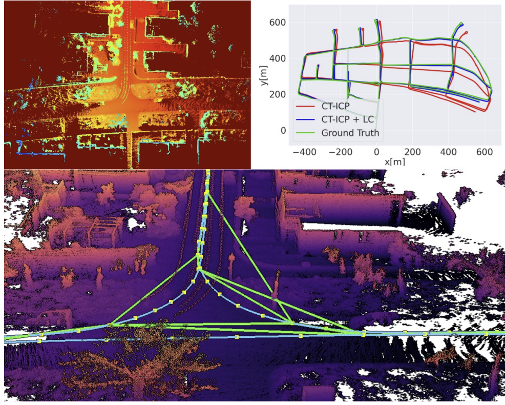
In one of our latest projects, we were thrilled to work with INRAE Clermont-Auvergne-Rhone-Alpes on a critical initiative: detecting dangerous slope angles in real-time along a tractor’s future trajectory using onboard LiDAR. The goal? Prevent rollovers on steep terrain by giving the tractor’s control system early warnings about hazardous inclines.

 Why it’s important: Tractor rollovers are a major safety risk in agriculture. By anticipating slope changes ahead of the vehicle, we can help operators and automated systems avoid dangerous situations—improving both safety and operational efficiency.

 How we made it happen:

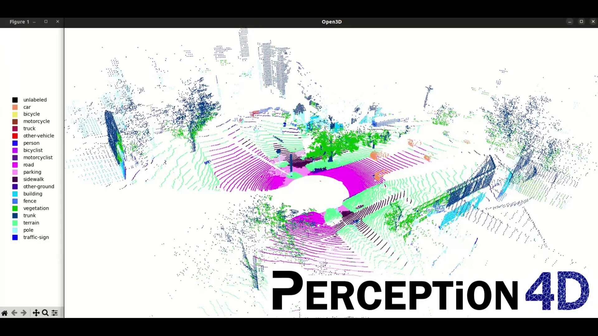
  • LiDAR + Point Cloud Analysis: We started by helping select the right LiDAR and optimize its positioning on the vehicle. Then, we processed dense 3D point clouds and IMU data to map the terrain and calculate surface normals, identifying slope angles in real time.
  • ROS2 pipeline and CAN integration: take advantage of state of the art real time technologies and ensure seamless communication with the tractor’s control unit.
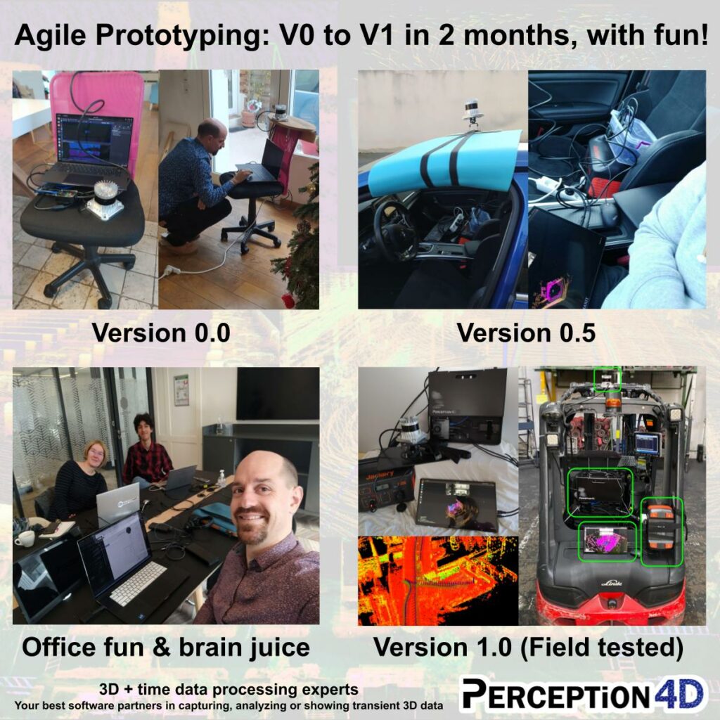
  • Rapid Iteration: Thanks to close collaboration with INRAE, we quickly refined the solution to match exactly their needs and specifications.

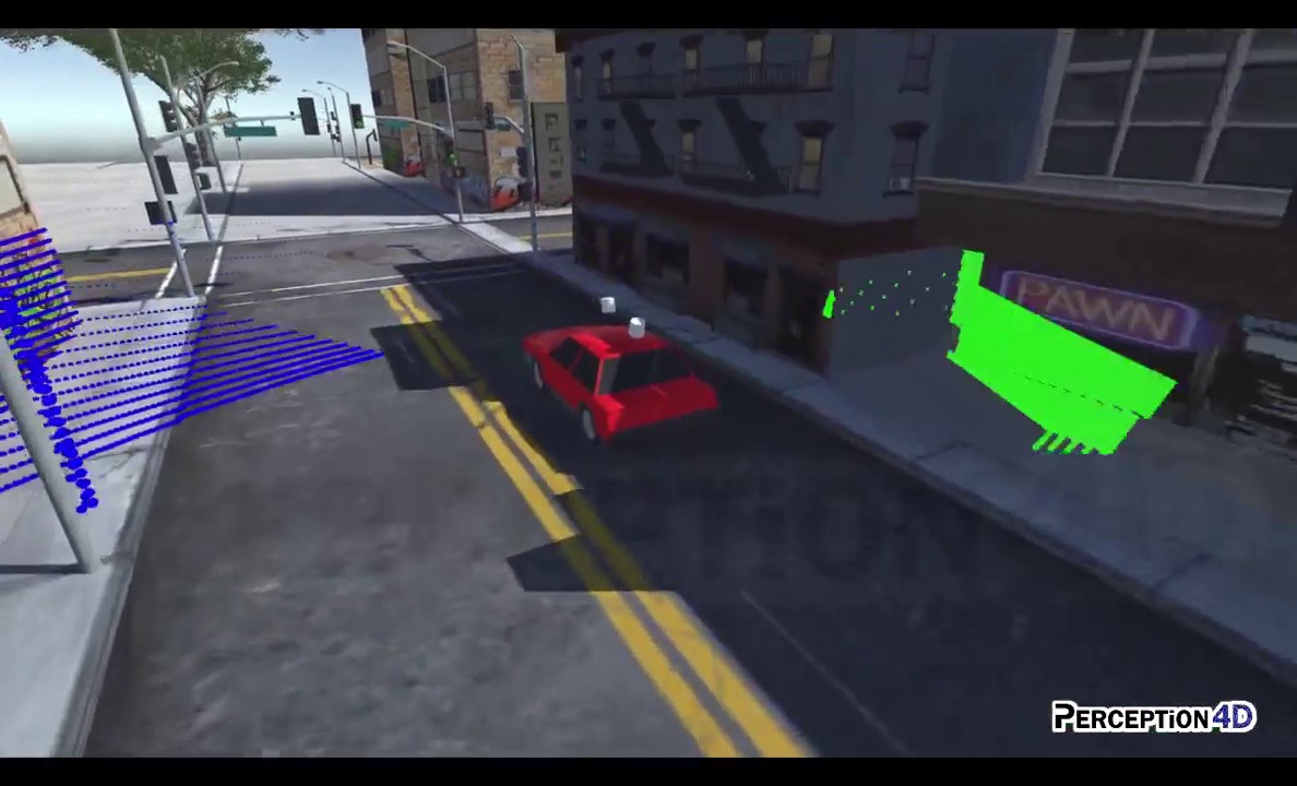
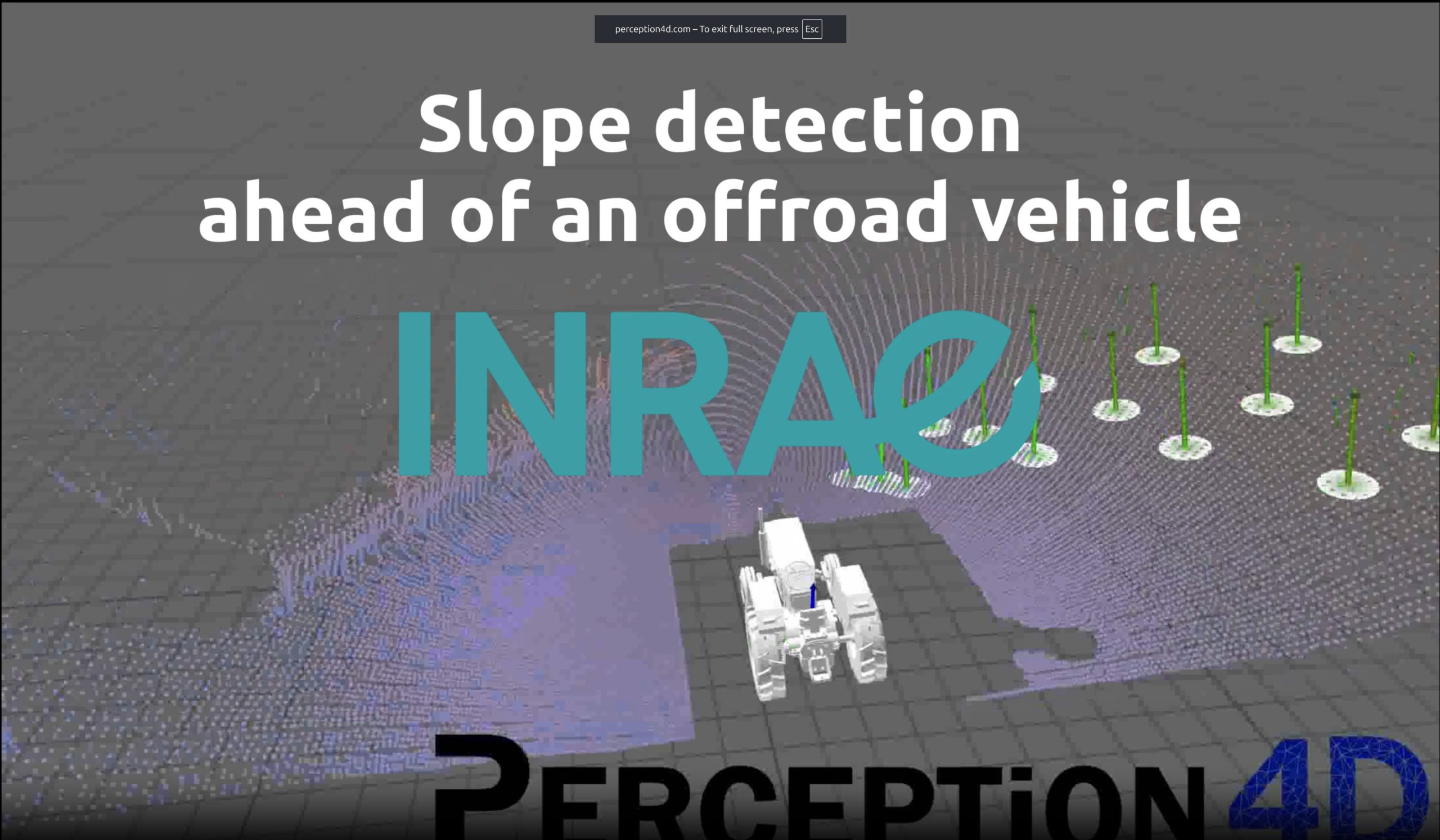
See it in action in the video below: The tractor’s projected trajectories, the LiDAR point clouds transformed back in the environment’s frame and the slope normals colored by potential rollover risks—all in real time!

This project showcases how Perception4D’s expertise in 3D and 4D perception (3D + time) can elevate your projects in autonomous vehiclesmobile robotics, or any industrial applications using 3D sensors, (LiDAR, RGBD cameras, etc.).

Working on something similar? Let’s talk! We’d love to explore how we can collaborate to turn your 3D data into actionable solutions.

#LiDAR #ROS2 #AgriculturalRobotics #CANBus #3DPerception #SafetyInnovation #INRAE #PointCloud #AutonomousVehicles #3D #mobileRobot #RobotPerception

Point Cloud Segmentation

🚀 A glimpse into a building block of a bigger project: Lidar point cloud segmentation, with only 3D points a Ouster OS1-128 Lidar.

🚗That’s the daily task of Autonomous Vehicles, and Perception4D applies to many other usages

🤖 Benchmarking and Retraining Deep Learning networks on inhouse data, from old-ish RandLanet PointPillars to KPConv and SuperPoint Transformer

💻 The direct usage goes from cleaning the scanned point cloud to computing road surface or cable length. And that’s a building brick for other projects.

🤝A huge thanks to Youssef OUCHOUID who work on this during his end of study internship supervised by Manon Cortial-Picard & Bastien Jacquet

LiDAR Simulator POC on Unity

🆛 Simulator for a two 360° LiDAR car-scanner, to tune their position & scanning coverage. Proof of concept done in a few hours using #Unity3D, building on past #UE5 work. (Sorry for quick-and-shaky video 😊)
Stay tuned for the corresponding real-world data 😉

Added value:
↪ 📐 Design: Choose the best Lidar positioning for robot field of view coverage.
↪ 🤖 Robotics: Test the algorithms with a controlled, synthetic, LiDAR datastream.
↪ 🎥 Surveillance: Place the Lidar at the best position covering intersection or parking spots.
↪ 📷 Lidar Manufacturers: Optimize laser directions and assembly for specific needs.

🚀 Combined expertise in Robotics, Lidar and Visualization get us pretty quick to prototype 4D (3D+time) data analysis in hours.

💻 Perception4D take your R&D concept to a tailored prototype in record time.

1 year taking R&D concepts to tested prototypes


🚀 One year ago, we were two LiDAR and 3D visualization experts, very excited to offer our expertise in 3D and 4D (3D+time) data analysis. 
We were a bit anxious about finding enough projects to sustain our business and have fun.

👨‍⚖️ One year later, Perception4D is 4 people strong, having fun running multiple projects including SLAM and robotics, multi lidar integration and point cloud machine learning & AI.

💻 We are the 4D Perception experts who can take your R&D concept to a tailored prototype in record time.

🎉 We are so glad to have jumped in this thrilling adventure ! 
🎂 Happy 1-year anniversary Perception4D !

The project here was about localisation and mapping, and was efficiently run thanks to the great power of opensource softwares:

  • LidarView I created years ago
  • SLAM algo KISS-ICP (by Ignacio Martin Vizzo, Tiziano Guadagnino, Benedikt Mersch, Louis Wiesmann, Jens Behley, and Cyrill Stachniss)
  • SLAM algo CT-ICP (by Pierre Dellenbach, Jean-Emmanuel Deschaud, Bastien Jacquet, François Goulette)

Thanks to our amazing team :
Joachim Pouderoux, Manon Cortial-Picard, Bastien Jacquet, Youssef OUCHOUID, Nikos Paragios
#robotics #lidar #slam #3Dperception #agile

🎉 She’s here! Manon just joined the Perception4D team. Our new partner is ready to tackle any LiDAR, SLAM or point cloud challenge you may have!

🎓 She has a 10y+ background in robotics, computer vision and AI, and expertise in embedded software for industrial 3D printing. As a qualified expert in 3D data analysis, she will ensure high quality counseling and robust programming on your 3D projects.

🚀 Need a hand on mobile robotics SLAM? 3D computer vision? Point cloud data analysis? Contact us!

🔎Want more?
👉Visit us / contact us via perception4d.com
👉Follow us on LinkedIn : Perception4D, Bastien Jacquet, Joachim Pouderoux, Manon Cortial, Nikos Paragios.

🚨🚗🤖 Perception4D had already many projects going on, so the team had to grow. (And let’s be honest, bigger team means more fun! ).
💪😍 Amid the job market craziness in Computer Vision, Perception4D’s offer for innovative projects, small team and direct company direction involvement attracted many, hence it took only two weeks finding our Senior Computer Vision & Partner.
[So no need anymore to hurry up and mail us your CV: we will still read it, but priority is now our marvelous projects.]

🎉🤝👨‍⚖️ Perception4D found a rare gem: a Partner eager to tackle the amazing projects of our coming years.

🎓💻🆛 She will enhance Perception4D’s expertise in Robotic, Computer Vision, SLAM, and AI;

😊🌎🚀 We look forward to share her enthusiasm which convinced us, her experience in collaborative projects, and her passion and knowledge of autonomous innovative machines & robots.

Stay tuned for details 😉

🔎Want more?
👉Visit us / contact us via perception4d.com
👉Follow us on LinkedIn : Perception4D, Bastien Jacquet, Joachim Pouderoux, Nikos Paragios, our rare gem (soon).

#hiring #computervision #LiDAR #LiDARView #Robot #SLAM #AI

We just learnt that the ICRA 2022 paper “CT-ICP: Real-Time Elastic LiDAR Odometry with Loop Closure” by Pierre Dellenbach, Jean-Emmanuel Deschaud, Bastien Jacquet, François Goulette has been selected as one of three finalists for the ICRA 2022 Outstanding paper awards!

Fig. 1: Top, in color, one LiDAR scan; the color depends on the timestamp of each point (from the oldest in blue to newestin red). The scan is deformed elastically to align with the map (white points) by the joint optimization of two poses at the start and end of the scan and interpolation according to the timestamp, hence creating a continuous-time scan-to-map odometry. Below, the formulation of our trajectory with a continuity of poses intra-scan and discontinuity between scans.

Fig. 2: Aggregated point clouds for NCLT dataset (top left), KITTI-CARLA (top-right), Newer College Dataset (bottom left), and ParisLuco (bottom right) show the quality of the maps obtained with CT-ICP.

Fig. 4: Qualitative results of loop closure on the sequence 00 of KITTI-360 (11501 scans). The top left is an elevation image built by projecting the local map. The top right shows both the CT-ICP odometry’s trajectory and the one corrected using the computed Loop Closure constraints (CT-ICP+LC). The bottom shows the different loop closure constraints (green) found for the same turn as the local map at the top left.

Contributions:
• New elastic LIDAR odometry based on the continuity of poses intra-scan and discontinuity between scans.
• Local map based on a dense point cloud stored in a sparse voxel structure to obtain real-time processing speed.
• Large campaign of experiments on 7 datasets in driving and high-frequency motion scenarios, all reproducible with public and permissive open-source code (C++ & Python bindings).
• Fast method of loop detection integrated with a pose graph back-end to build a complete SLAM, integrated into pyLiDAR-SLAM.

Congrats to Pierre Dellenbach, Jean-Emmanuel Deschaud, Bastien Jacquet, François Goulette !
(And especially the first two for the hand-on coding sessions over the summer 🙂 )

You can download the full article on arXiv and HAL.